Waymo and Wayve launch robotaxis in London with opposing approaches
Waymo and Wayve have launched robotaxis in London at the same time. Waymo bets on a large sensor suite and detailed 3D maps of every street. Wayve has taken a different path: it relies on cameras and machine learning trained on data from many cities. London is the first place where the two strategies meet in the real world.
AI-processed from Bloomberg Tech; edited by Hamidun News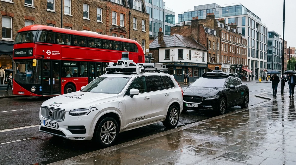
Waymo and Wayve launched robotaxis in London almost simultaneously. This is not just competition for a market; it is a historic clash between two opposing philosophies of building autonomous cars. Both companies are absolutely convinced that their approach will dominate the future of mobility, and London is where that conviction will be tested against reality.
Waymo's philosophy: sensors, maps and engineering precision
Waymo chose the path of traditional engineering. Each vehicle carries many high-tech sensors: lidars (laser 3D scanners), spatial radars, stereo cameras and high-resolution monocameras. This multi-sensor system sees the world with redundancy: if one sensor fails, the others keep working.
But what is truly unique about Waymo is its maps. The company builds and constantly updates hyper-precise 3D digital maps of every route and street. These maps record the position of every lane marking, every road sign, the height of the curb, the position of the traffic light: literally everything a car needs to know about its surroundings.
Before launching in a new city, Waymo sends teams of specialists who spend many months collecting and processing data. Human annotators manually check that the car understands road scenes correctly. It is expensive and slow, but safe.
The strategy has worked. Waymo operates safely in San Francisco, Phoenix, Los Angeles, San Diego, Austin, Las Vegas and other large American cities. But Waymo's approach has an Achilles' heel: it demands huge capital investment and time. Expanding into a new territory means a months-long marathon of data collection, annotation and validation, and only then the car's first drive on the streets.
Wayve bets on pure AI and global scalability
Wayve sees the future very differently and rejects the concept of detailed mapping. Instead, the company relies on computer vision and deep machine learning trained on a colossal volume of video data.
Wayve's cars are equipped with cameras, but the machine-learning task is fundamentally different. The system does not learn from the data of one specific route, but from the aggregated experience of hundreds and thousands of cars driving through different cities, in different conditions, in different seasons and at different times of day. The neural network learns to recognize typical road scenes, the behavior of pedestrians and cyclists, and the actions of other drivers, not tied to a specific geolocation but as universal patterns that transfer between cities.
Wayve claims its system already works in London and other European cities with minimal advance preparation. The company says it can expand much faster, because it does not need a months-long marathon of map collection and annotation before each launch. A new city is simply new video data feeding the existing neural network.
London: the historic meeting point of two worlds
London is the first city where both approaches have launched at the same time in real commercial conditions. This is no coincidence; it is a chance to see which philosophy works better, which is safer, which is more economical.
The test will last months and years. Observers will track safety, reliability, speed of expansion and operating costs. The industry is frozen in anticipation:
- Which method will deliver the best safety in real London conditions?
- Can Wayve's system, without detailed maps, function reliably in a new city?
- Which approach is cheaper when scaling to tens and hundreds of cities?
- Who will reach operational profitability first?
- Which approach will win more investment and consumer trust?
What this means for the future
The outcome of the London test will shape the architecture of global mobility for a decade. If Wayve is right, robotaxis will be available in all major cities of the world much sooner and significantly cheaper than experts currently assume. That means the era of human driving will end faster than many think.
If Waymo is right, investment in high-precision mapping and multi-sensor systems will pay off, but global expansion will stay slow, capital-intensive and concentrated in a few large cities. In that scenario, robotaxis become a premium-segment product, available only in developed countries.
London has become a natural proving ground for two visions of the future. Over the next few years, the whole world will watch the results.
- Nov 1, 2026Adobe's EditAgent judge picks a usable edit 81.3% of the time, versus 74.8% for EditScore
- Nov 1, 202616 models tested on 7 search tools: Exa averaged 10.5 out of 14, SearXNG about 3
- Nov 1, 2026Google's StreamVibe video agent beats other models by 10.7% on response timing and quality
- Nov 1, 2026New test catches hidden AI agent collusion by measuring how a partner reacts to a paraphrase
Key Questions Answered
What are the key details on Waymo's philosophy: sensors, maps and engineering precision?
Waymo chose the path of traditional engineering. Each vehicle carries many high-tech sensors: lidars (laser 3D scanners), spatial radars, stereo cameras and high-resolution monocameras. This multi-sensor system sees the world with redundancy: if one sensor fails, the others keep working. But what is truly unique about Waymo is its maps. The company builds and constantly updates hyper-precise 3D digital maps of every route and street. These maps record the position of every lane marking, every road sign, the height of the curb, the position of the traffic light: literally ev
What are the key details on Wayve bets on pure AI and global scalability?
Wayve sees the future very differently and rejects the concept of detailed mapping. Instead, the company relies on computer vision and deep machine learning trained on a colossal volume of video data. Wayve's cars are equipped with cameras, but the machine-learning task is fundamentally different. The system does not learn from the data of one specific route, but from the aggregated experience of hundreds and thousands of cars driving through different cities, in different conditions, in different seasons and at different times of day. The neural network learns to recognize
What are the key details on London: the historic meeting point of two worlds?
London is the first city where both approaches have launched at the same time in real commercial conditions. This is no coincidence; it is a chance to see which philosophy works better, which is safer, which is more economical. The test will last months and years. Observers will track safety, reliability, speed of expansion and operating costs. The industry is frozen in anticipation: Which method will deliver the best safety in real London conditions? Can Wayve's system, without detailed maps, function reliably in a new city? Which approach is cheaper when scaling to tens a
Test Frontier LLMs & Autonomous Agents in One Workspace
Run Claude Opus 5.5, GPT-6, Gemini 3.1, and DeepSeek side-by-side in Nomad AI (nomadnet.ai) — unified model routing, deep research, and multimodal workflows under one subscription.
The AI world, distilled — once a week
Seven stories that actually mattered, hand-picked. No noise, no reposts, no press releases.
Done! Check your inbox for a confirmation.